Land Use Consent
If a rule is breached under the District Plan, resource consent approval is required for the proposed activity. For Council to assess your application, it helps if the relevant information is all provided and the plans are detailed and easy to read for the Council Planner to have a good understanding of your proposed activity when processing your consent. This will help reduce delays, misunderstanding and potential cost.
you require Land Use consent:
- Complete and sign the application form for Land Use Consent approval.
- Check the District Plan to find which rule/s are breached which is defined by the zone of the property i.e for residential, business or rural. Please state the rule/s breached within your application.
- Describe your proposal. The amount of information the Council requires will depend on the activity proposed and the scale of that activity.
- Complete an Assessment of Environmental Effects (AEE). Every resource consent application has to have an AEE. This can be done on a separate document, titled Assessment of Environmental Effects.
Please note: ‘A Guide to Preparing a Basic Assessment of Environmental Effects’ is available on the Ministry for the Environment’s website: www.mfe.govt.nz
- Identify who might be interested in or affected by your proposed activity and how they might be affected (this might require consultation). Under the RMA, an ‘affected person’ is a person or organisation who the council thinks will experience an adverse effect from your proposal that is "minor" or "more than minor" (but not "less than minor"). A final decision on who is an ‘affected party’ is decided during processing of your application. Please note: If gaining affected persons approval, discuss your proposal with them, show them your application and all owners and occupiers of the property will need to sign Affected Persons form and sign the application plans.
- Provide plans to support your application i.e site plan – including buildings (proposed and existing), access, car parking, landscaping. Floor plan of the internal layout and elevations of any proposed buildings.
- A current Certificate of Title (current within 3 months).
- Consider if you need to employ an expert to help you prepare the information i.e for complex projects like quarries, motels/hotels and larger type commercial developments you may need the commissioning of specialist reports such as traffic and noise reports prepared by a suitably qualified person and project managed by a private planning consultant or for a proposed comprehensive residential development you may like to consult with an urban designer.
Electronically:
All resource consent applications may be emailed to: RCApplications@wmk.govt.nz
Post:
Planning Department
Waimakariri District Council
Private Bag 1005
Rangiora 7440
Or, handed to the Council:
Rangiora Service Centre located at 215 High Street, Rangiora
Once the decision has been granted, Council will email and post the person/ company that was noted under the ‘address for service’ on the application form.
When a resource consent is granted, it is subject to certain conditions, i.e supplying an Environmental Management Plan. It is the responsibility of the land owner to comply with any conditions set in the resource consent approval. The Council may undertake monitoring, including a phone call or site inspection, to make sure that conditions are complied with.
Note: a resource consent lapses five years after the decision has been issued if the proposal
Subdivision Consent
Subdivision is a process of dividing a parcel of land or a building into one or more further parcels, or changing an existing boundary location. There are different types of subdivision including the creation of fee simple, unit title, cross lease and leasehold titles which all require a subdivision consent.
To apply for subdivision approval, Council generally require the following information:
- A subdivision consent application form, needs to completed and signed.
- Complete an Assessment of Environmental Effects (AEE). Examples of AEE’s are on the Ministry of Environment’s website. Link to ‘A Guide to Preparing a Basic Assessment of Environmental Effects’ is available on the Ministry for the Environment’s website: www.mfe.govt.nz
- A scheme plan / survey plan (showing proposed allotment numbers, sizes and dimensions, and proposed building platforms).
- A recent copy of a certificate of title (current within 3 months).
- Matters under Section 106 of the RMA require to be addressed.
- An assessment of the potential for site contaminants in soil, by using one of the methods identified in clause 6 of the National Environmental Standard for Assessing and Managing Contaminants in Soil to Protect Human Health regulations (NESCS).
- If your development contains new roads/streets you may submit a choice of up to 3 names for each new road/street for consideration by the local Community Board.
- Further documents to support your subdivision proposal.
- The application fee and additional lot(s) fee (as listed under fees and charges)
How to lodge your application:
All resource consent applications may be emailed to: RCApplications@wmk.govt.nz or posted to:
Planning Department
Waimakariri District Council
Private Bag 1005
Rangiora 7440
Applications can also be dropped off to the Rangiora Service Centre located at 215 High Street, Rangiora.
Once the decision has been approved for the subdivision consent, and before new certificates of titles can be issued for the new allotments, there are two more key stages that need to be completed within a subdivision process.
Once Council have issued the decision for the subdivision consent, a s.223 certificate is required to be applied for within five years of the decision being issued. A s.223 Certificate, is a certificate which the Council approves when a subdivision has had its final survey.
This s.223 certificate may only be applied for by a Registered Surveyor through Land Information New Zealand (LINZ). The s.223 certificate is required to include any amalgamations, easements and access arrangements (Rights of Way) for all lots. The 223 Certificate is signed electronically through LINZ, only after being checked that it matches the approved plan which was approved as part of the subdivision consent.
Once a s.223 certificate has been signed by Council, then a s.224 (c) certificate must be obtained within three years from the date of signing the s.223 certificate. The s.224(c) certificate is issued by the Council once all the conditions which were imposed on your subdivision consent have been met. The processing of a s.224(c) certificate requires Council Officers to review the supporting documentation supplied (including as built plans showing new services), site inspection(s), confirmation that the relevant development contributions have been paid and undertake an assessment to check that every condition imposed on the subdivision consent has been met.
Consent notices are manual certificates, prepared by the Council at the same time as the s.224c certificate. A s.221 consent notice is a condition between the Council and a land owner and can only be imposed through subdivision consent. Any consent notices imposed on your subdivision consent will be registered on the new Certificate of Titles alerting current and future property owners of certain obligations that must be complied with after the Certificate of Title has been issued or, in some cases, on a continuing basis by the owner, and subsequent owners, of a property.
As a consent notice is an agreement between the Council and the land owner, it is the responsibility of the landowner and the Council to check compliance. If a consent notice is relating to construction of building work or services, this will be checked at the building consent stage. Some consent notices may be varied or cancelled through an application process. To vary/cancel a consent notice, please see the variation application form and the Council’s fees and charges page for costs.
Once Council is satisfied that all conditions of subdivision consent have been complied with, then the s.224(c) certificate will be signed electronically through LINZ. Titles will be issued with any consent notices, if they were required in your subdivision decision. Once this has been completed, they are lodged with LINZ by your solicitor.
Please find link for application form to apply for 224 certificate.
Flood Assessment Certificates (FAC) and Coastal Flood Assessment Certificates (CFAC)
You may have heard about Flood Assessment Certificates and Coastal Flood Assessment Certificates, or you may have been told you need one. The following information describes what they are, when and where they’re needed, and how to apply.
To meet obligations under the Resource Management Act 1991, minimum floor level requirements and processes are now in place under the Partially Operative Waimakariri District Plan to ensure that certain buildings are constructed with a minimum finished floor level that would mean they are unlikely to be flooded by a 0.5% (1 in 200-year) Annual Exceedance Probability Flood Event.
If a building platform for a new Natural Hazard Sensitive Activity or Above Ground Critical Infrastructure is located within a mapped ‘Flood Assessment Overlay’ shown on District Plan, a Flood Assessment Certificate (FAC) is now required to be sought for a fee of $200 (inclusive of GST) and issued by the Council, before commencing building work for any new buildings (greater than 25m2), or additions of at least 25m2 or larger to existing buildings, which:
- Contain at least one habitable room; or
- Serviced with a sewage system and connected to a potable water supply; or
- A place of assembly; or
- An above ground critical infrastructure.
For the following circumstances a Flood Assessment Certificates or Coastal Flood Assessment Certificates is not required:
- Sites not located within an Urban Flood Assessment Overlay, Non-Urban Flood Assessment Overlay, Coastal Flood Assessment Overlay, or Special Purpose Rangiora Airfield Zone identified under Partially Operative Waimakariri District Plan;
- Sites subject to a resource consent condition specifying a minimum finished floor level for that activity where the resource consent decision was issued within 5 years from the issuing of the building consent.
- Non-Urban sites which the building platform will be within a High Hazard Area, this will require resource consent approval instead.
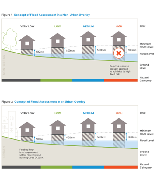
In Urban areas, a minimum finished floor level is required to be the following:
- In very low areas = New Zealand Building Code NZBC applies
- In low areas = 400mm above the flood level of a 0.5% AEP (1 in 200-year); or
- In Medium to High Hazard Area = 500mm above the flood level of a 0.5% AEP (1 in 200-year) Flood Event.
In Non-Urban areas, a minimum finished floor level is required to be the following:
- Very low area = 400mm above undisturbed ground at any point intersecting the building footprint
- In low areas = 400mm above the flood level of a 0.5% AEP (1 in 200-year); or
- In Medium Area = 500mm above the flood level of a 0.5% AEP (1 in 200-year) Flood Event.
Note: In Non-Urban High Hazard Area a Resource Consent is required for the building.
Kaiapoi
Certain areas of Kaiapoi are subject to High Hazard flooding in the 500-year (0.2% AEP) event. For sites affected by High Hazard in the 0.2% AEP event, further assessment of the risk to life from the proposed development will be needed. If you are planning to develop a site in Kaiapoi, please contact Council early using the box below to confirm the flood hazard the site is subject to. Meeting the minimum finished floor level requirements may not automatically mean the development can progress.
For further clarification, please refer to concept figures below:
Figure 1 – Concepts of Flood Assessment
Advice notes:
There are several exclusions that apply; please refer to rules NH-R1, NH-R2, NH-R3 and the definition of ‘natural hazard sensitive activities’ for further details.
Infrastructure may require a Flood Assessment Certificate, please refer to rules NH-R1, NH-R2, NH-R3 and NH-R5 and the definition of ‘natural hazard sensitive activities’ and ‘above ground critical infrastructure’ for further details.
Please complete template and the Council will respond within 5 working days to advise if a flood assessment certificate is required.
To apply for a Flood Assessment Certificate or Coastal Flood Assessment Certificate, please submit an application using this form.
What information should be included in the application for a Flood Assessment Certificate or Coastal Flood Assessment Certificate?
An application for a Flood Assessment Certificate or Coastal Flood Assessment Certificate requires the following:
- Completed application form that sets out contact details and description of activity
- Indicative site plan that includes the proposed minimum finished floor:
- Note that applications for activities located within a Non-Urban Flood Assessment Overlay may be required to provide a grid location and site plan that shows the proposed location of the building on site. Where a site is larger than 500m2, a plan showing the location of any proposed Natural Hazard Sensitive Activity buildings and grid reference is required.
- Confirmation or certification of ground level:
- Applications for activities located within a single urban site within the Urban Flood Assessment Overlay must provide confirmation of the site’s existing ground levels from a Licensed Cadastral Surveyor. Levels are to be in NZVD 2016 datum, and identify the permanent benchmark used as the reference point which can also be used during the build.
- Record of Title (issued within the last 3 months and including any consent notices)
- Any building consent or resource consent references
- Any other relevant documents supporting your application.
Lodgement of your application:
- Via email (up to 22MB) to: FACApplications@wmk.govt.nz
- Via post to: Waimakariri District Council, Private Bag 1005, Rangiora, 7440
- Dropped off at any Waimakariri District Council service centre:
- Rangiora (215 High Street, Rangiora)
- Kaiapoi (Ruataniwha Kaiapoi Civic Centre, 176 Williams Street, Kaiapoi)
- Oxford (34 Main Street, Oxford)
How much will a Flood Assessment Certificate or Coastal Flood Assessment Certificate cost?
A Flood Assessment Certificate or Coastal Flood Assessment Certificate has a fixed fee of $200.00 (inclusive of GST) per application.
How long is a Flood Assessment Certificate or Coastal Flood Assessment Certificate valid for?
A Flood Assessment Certificate or Coastal Flood Assessment Certificate is valid for 3 years from the date of issue.
You will not need to apply for Flood Assessment Certificates or Coastal Flood Assessment Certificates for the following circumstances:
- Sites not located within an Urban Flood Assessment Overlay, Non-Urban Flood Assessment Overlay, or Coastal Flood Assessment Overlay identified under Partially Operative Waimakariri District Plan;
- Activities on sites subject to a specified minimum finished floor requirement imposed as a consent notice and registered, or to be registered, on the Record of Title.
- Sites subject to a resource consent condition specifying a minimum finished floor level for that activity where the resource consent decision was issued within 5 years from the issuing of the building consent.
- Non-Urban sites which are within a High Hazard Area, will require resource consent approval instead.
What is a Flood Assessment Certificate or Coastal Flood Assessment Certificate?
A Flood Assessment Certificate or Coastal Flood Assessment Certificate is a certificate issued by the Waimakariri District Council that certifies whether a building is likely to be subject to flooding and, if it is, the minimum finished floor level required by the Partially Operative District Plan to mitigate the risk of flooding in a 200-year flood event.
Why does Council require a finished floor level to be above the modelled flood level?
The reason Council requires buildings to have a minimum finished floor level to be 400mm (low hazard areas) and 500mm (medium/high urban hazard areas) above the modelled flood level (known as a ‘freeboard’) is to protect the building from water ingress, account for potential uncertainties in flood modelling, wave and wind effects, network failures, and construction tolerances.
How do I know if I need to apply for a Flood Assessment Certificate or Coastal Flood Assessment Certificate?
Flood Assessment Certificates or Coastal Flood Assessment Certificates are required for all residential units (houses), or additions to residential units which are larger than 25m² in gross floor area, a place of employment, or a place of assembly (e.g., churches and community halls), and above ground critical infrastructure, where the building is located within a Flood Assessment Overlay or Coastal Flood Assessment Overlay under the Partially Operative Waimakariri District Plan (2025 version). To check if your site is within an Urban Flood Assessment Overlay, Non-Urban Flood Assessment Overlay, or Coastal Flood Assessment Overlay, you can search the address on the Partially Operative Waimakariri District Plan and select the relevant overlay on the left-hand side of the page.
What if the Building Act 2004 requires a different minimum finished floor level to that required by the Flood Assessment Certificate or Coastal Flood Assessment Certificate?
If the minimum finished floor level required by the certificate differs to the minimum finished floor level required by the Building Act 2004, the higher minimum finished floor level will be required to obtain building consent.
What information is available to staff to help determine an appropriate finished floor level?
- Flood Model Results (canterburymaps.govt.nz)
- The Waimakariri District Council flood model
- Flood model results undertaken as part of a recent subdivision but not yet incorporated into the flood model held on Canterbury Maps, nor the Waimakariri District Council flood model database.
- ‘As built’ earthworks plans prepared by a subdivision developer as part of the subdivision process.
The 1 in 200 year (0.5% AEP) flood hazard modelling is available at the Waimakariri District Natural Hazards Interactive Viewer.
Just click on the “Flooding” tab towards the top of the page and it will take you to interactive maps where you can enter an address and get information on the flood hazard and flood depths relevant to the site.
How long will it take Council to issue a Flood Assessment Certificate or Coastal Flood Assessment Certificate?
Council aims to issue a site-specific Flood Assessment Certificates within 10 working days from the date the application fee is received. However, more complex applications may take longer to process.
How did this Flood Assessment Certificate and Coastal Flood Assessment Certificate process come into effect?
The Flood Assessment Certificate and Coastal Flood Assessment Certificateprocess have been introduced by new provisions within the Natural Hazards chapter of the Partially Operative District Plan. It was part of the notified version of the Proposed Waimakariri District Plan (notified on 18 September 2021), and the Council decision version of the Partially Operative Waimakariri District Plan was publicly notified on Monday 14 July 2025. This is the date these new rules begin to apply.
What happens if my activity is in a High Hazard Area within the Non-Urban Flood Assessment Overlay?
Buildings that are considered ‘natural hazard sensitive activities’ proposed to be constructed on land within a High Hazard Area in a Non-Urban Flood Assessment Overlay require a resource consent. Please contact the Duty Planner for more information (duty.planner@wmk.govt.nz).
Why do Flood Assessment Certificates and Coastal Flood Assessment Certificates lapse after 3 years?
Where building work does not proceed within 3 years of the Flood Assessment Certificate or Coastal Flood Assessment Certificatebeing issued, the Flood Assessment Certificate will lapse, and the applicant will need to apply for a new one.
This is a requirement under the Partially Operative Waimakariri District Plan because the Council’s flood modelling continues to be updated with new information as new subdivisions are developed and as other new flood hazard information becomes available. This 3-year period gives applicants the certainty to proceed with building design with a known minimum finished floor level, but ensures that up to date information is used to determine the appropriate finished floor level.
What are ‘Natural Hazard Sensitive Activities’?
means buildings and conversions of existing buildings which:
- contain one or more habitable rooms; or
- are serviced with a sewage system and connected to a potable water supply; or
- are a place of assembly;
except that this shall not apply to:
- infrastructure or critical infrastructure;
- any detached garage to a residential unit or minor residential unit that is not a habitable room;
- any building with a footprint of less than 25m2;
- any building addition in any continuous 10-year period that has a footprint of less than 25m2; or
- any building with a dirt/gravel or similarly unconstructed floor.
What is ‘above ground critical infrastructure’?
The Partially Operative Waimakariri District Plan defines ‘above ground critical infrastructure’ as:
Infrastructure necessary to provide services which, if interrupted, would have a serious effect on people and communities and which would require immediate reinstatement. This includes any structures that support, protect or form part of critical infrastructure. Critical infrastructure includes:
- regionally significant airports;
- regionally significant ports;
- gas storage and distribution facilities;
- electricity substations, networks, and transmission and distribution installations, including the National Grid and the electricity distribution network;
- supply and treatment of water for public supply;
- stormwater and sewage treatment and disposal systems;
- radiocommunication and telecommunication installations and networks;
- strategic road and rail networks;
- petroleum storage and supply facilities;
- public healthcare institutions including hospitals and medical centres;
- fire stations, police stations, ambulance stations, emergency coordination facilities;
except that critical infrastructure excludes a service, facility or connection that does not have a public or community function.
Note - Rule NH-R5 does not apply to above ground critical infrastructure that is roads.
The District Council will issue a Flood Assessment Certificate (which will be valid for three years from the date of issue) that specifies:
- whether the activity is located on a site that is within a high hazard area; and
- whether the activity is located within an overland flow path; and
- where the activity is located on land that is within the Urban Flood Assessment Overlay, the minimum finished floor level in accordance with (e); or
- where the activity is located on land that is within the Non-Urban Flood Assessment Overlay and is located on land that is outside of a high hazard area, the minimum finished floor level in accordance with (e); and
- the minimum finished floor level shall be calculated as the highest of the following:
- flooding predicted to occur in a 0.5% AEP (1 in 200-year) Localised Rainfall Event plus up to 500mm freeboard (including allowances for climate change); or
- flooding predicted to occur in a 0.5% AEP (1 in 200-year) Ashley River/Rakahuri Breakout Event concurrent with a 5% AEP (1 in 20-year) Localised Rainfall Event plus up to 500mm freeboard (including allowances for climate change); or
- flooding predicted to occur in a 0.5% AEP (1 in 200-year) Storm Surge Event concurrent with a 5% AEP (1 in 20-year) River Flow Event with an allowance for sea level rise, plus up to 500mm freeboard.
Freeboard will be applied as follows:
- Low Hazard - 400mm freeboard
- Medium to High Hazard - 500mm freeboard
Advisory Notes
- An application form and guidance on how to obtain a Flood Assessment Certificate are available on the District Council's website.
- Certificates are valid for three years from the date of issue. If a land use consent is required, the five year period provided under the RMA to give effect to the resource consent overrides the three year Certificate lifespan.
- Under NH-S1 the District Council will not provide a required minimum floor level for high hazard areas within the Non-Urban Environment Flood Assessment Area. A resource consent will be required in this situation.
- Further information on hazards including technical reports and hazard maps identifying areas potentially subject to freshwater flooding, sea water inundation flooding and areas that are potentially a high hazard area can be found at the Waimakariri District Natural Hazards Interactive Viewer. This further information does not form part of the District Plan.
- The AEP flood event risk level, minimum floor levels and overland flow path locations are to be determined by reference to:
- The most up to date models, maps and data held by the District Council and the Regional Council; and
- Any information held by, or provided to, the District Council or the Regional Council that relates to flood risk for the specific land.
- The inclusion of climate change allowances should always be based on the latest government advice and the latest available data. A 100 year horizon should be used wherever possible and if forecast values do not extend to 100 years then the longest available horizon should be used. The climate change or emissions scenario should align with the latest government advice. Note that emissions scenario RCP8.5 was used in 2021 to develop the current iteration of the District Plan.
The District Council will issue a Coastal Flood Assessment Certificate (which will be valid for three years from the date of issue) for a site within the Coastal Flood Assessment Overlay that specifies:
- whether the activity is located on a site that is likely to be affected by sea water storm surge flooding; and
- whether the activity is located on a site that is within a high hazard area; and
- where the activity is located on a site that is within the Non-Urban Flood Assessment Overlay and is outside of a high hazard area and (a) is met, the minimum land level in accordance with (d), or the minimum land and finished floor level combination in accordance with (e);
- the minimum land level shall equal:
- the flooding level predicted to occur in a 0.5% AEP (1 in 200-year) Storm Surge Event concurrent with a 5% AEP (1 in 20-year) River Flow Event with an allowance for sea level rise;
- the minimum land and floor level combination shall equal:
- land filled to be within 300mm of the required land level under (d); and
- a floor level that meets the minimum level specified in NH-S1.
Advisory Notes
- NH-S2 only applies for natural hazard sensitive activities outside the urban environment under NH-R15 and above ground critical infrastructure under NH-R16.
- An application form and guidance on how to obtain a Flood Assessment Certificate are available on the District Council's website.
- Certificates are valid for three years from the date of issue. If a land use consent is required, the five-year period provided under the RMA to give effect to the resource consent overrides the three-year Certificate lifespan.
- Under NH-S2 the District Council will not provide a required minimum floor/land level for high hazard areas within the Non-Urban Flood Assessment Area. A resource consent will be required in this situation.
- Further information on hazards including technical reports and hazard maps identifying areas potentially subject to freshwater flooding, sea water inundation flooding and areas that are potentially high hazard areas can be found on the Waimakariri District Natural Hazards Interactive Viewer. This further information does not form part of the District Plan.
- The AEP flood event risk level, minimum floor levels and overland flow path locations are to be determined by reference to:
- The most up to date models, maps and data held by the District Council and the Regional Council; and
- Any information held by, or provided to, the District Council or Regional Council that relates to flood risk for the specific land.
- Freeboard will be applied as follows:
- Low Hazard - 400mm freeboard
- Medium to High Hazard - 500mm freeboard
- The inclusion of climate change allowances should always be based on the latest government advice and the latest available data. A 100-year horizon should be used wherever possible and if forecast values do not extend to 100 years then the longest available horizon should be used. The climate change or emissions scenario should align with the latest government advice. Note that emissions scenario RCP8.5 was used in 2021 to develop the current iteration of the District Plan.
Other Approvals Under the RMA
Section 10 of the Resource Management Act 1991 refers to Existing Use Rights of a building or activity, before the rule was made operative in the District Plan or Proposed District Plan.
However, to replace a structure or continue an existing activity (land use) which does not have resource consent and would contravene a rule in the District Plan, a person may apply to the Council to issue an Existing Use Rights Certificate for a structure or activity to be documented as legally established.
For Council to process an application for Existing Use Rights, these standards are provided for under Section 10 of the Resource Management Act 1991, which are:
- The building or activity was lawfully established before the rule became operative into the District Plan or the Proposed plan was notified, and
- The effects of the land use are the same or similar in character, intensity, and scale to those which existed before the rule became operative into the District Plan or the Proposed Plan was notified, and
- The building or activity was not discontinued for a continuous period of more than 12 months after the rule in the plan became operative or the proposed plan was notified.
To apply for Existing Use Rights
- Complete the application form and sign.
- Provide plans of the building/ activity.
- Provide additional evidence the building/ activity is lawfully established.
- Application fee (this can be invoiced)
To submit your application
Email:
Post:
Private Bag 1005, Rangiora, 7440
Or handed:
To Council staff at Rangiora Service Centre, 215 High Street, Rangiora.
For the application fee, please refer to the Council’s fees and charges schedule
Designations are areas of land set aside for network utilities or large public works, i.e Highways, Telecommunications facilities, Schools and Airports.
Once a designation is in the District Plan (Chapter 35), the ‘Requiring Authority’ does not have to comply with the District Plan rules, but they do need to notify the Council by submitting an Outline Plan of Works or Waiver to the Outline Plan for work to be carried out on the designated site under Section 176A of the Resource Management Act 1991 (RMA).
The works must comply with the use of the site specified in the designation, i.e, building classrooms on a site designated for education purposes by the Ministry of Education.
Section 176A(3) requires that an Outline Plan must show:
- The height, shape, and bulk of the public work, project, or work; and
- The location on the site of the public work, project or work; and
- The likely finished contour of the site; and
- The vehicular access, circulation, and the provision for parking; and
- The landscaping proposed; and
- Any other matters to avoid, remedy, or mitigate any adverse effects on the environment. such as noise, dust, lighting, glare and odour as necessary.
- The purpose of the designation
An Outline Plan of Works is not always necessary for works within a designation.
The Requiring Authority can request that the Council waive the requirement for an Outline Plan of Works if it does not believe one to be necessary. Council are happy to discuss the potential for a waiver with the Requiring Authority initially before making the request in writing.
Waiver of Outline Plans
An Outline Plan of Works is not always necessary for works within a designation.
The Requiring Authority can request that the Council waive the requirement for an Outline Plan of Works if it does not believe one to be necessary. Council are happy to discuss the potential for a waiver with the Requiring Authority initially before making the request in writing.
When determining whether to waive the need for an Outline Plan, the Council considers:
- The level of effects that the proposed work or project may have.
- Whether the proposal or work would otherwise be a permitted activity and would meet any relevant performance standards of the underlying zone.
- Whether the effects of the works are addressed through a regional resource consent process
- Whether the information has already been provided to the territorial authority as part of the designation,
- Whether meeting the conditions of the designation provides adequate control and certainty.
Applying for an Outline Plan of Works
- Complete the application form and sign.
- Provide plans of the proposed works.
- Attached conditions imposed on the designation (if applicable).
From 18 October 2017 a number of amendments occurred to the Resource Management Act 1991 (RMA) that require Councils to implement. One key requirement from the resource consents process is an ‘exemption’ for boundary rules within the District Plan, i.e daylight recession planes and setback to a neighbouring property boundary.
Setbacks to boundaries along a road, rail corridor, reserve, river or other land owned by the Council or Crown, will not qualify to go through a ‘Permitted Boundary Activity’ if the setback is breached.
If you breach a boundary rule to a neighbouring property under the District Plan, you can apply for a Permitted Boundary Activity which requires specific information to be submitted into Council for approval.
All applications for a permitted boundary activity must be electronic and are required to be applied for only by the owner/s. The agent may not be the applicant.
How to apply for a Permitted Boundary Activity
- An application form for a Deemed Permitted Boundary Activity is required to be filled out and signed.
- The form for Written Approval for Deemed Boundary Activity is required to be completed and a copy of all the application plans need to be signed from all of the owners of the infringed properties to the non-compliance. Signatures from tenants are not needed for a Permitted Boundary Activity approval.
- A copy of the site plan, showing existing & proposed structure, floor plan and elevations.
- A current certificate of title (current within 3 months)
All information provided must be eligible and sufficient to confirm that no other District Plan rules are breached. There are no provisions under the RMA for the Council to request for further information for this type of application. Incomplete applications will be returned, then can be resubmitted.
What is a Certificate of Compliance?
A Certificate of Compliance is a formal confirmation from the Council that an activity carried out on a piece of land is permitted and/or is lawfully operating under the Council’s District Plan and will not need resource consent approval.
Anyone can apply for a Certificate of Compliance, and Council will produce a Certificate after a full assessment of the proposal has been done against all the rules of the District Plan. Council may request further information where compliance has not been clearly established. It is up to the land owner or person operating a specific activity on a piece of land to provide evidence that demonstrates how the activity is complying with the District Plan requirements.
NOTE: Once a Certificate of Compliance is approved and if the activity changes in the future, it is unlikely you will have protection under the original approval.
The applicant cannot apply, if:
- The request for a certificate is made after a proposed Plan is notified; and
- The activity could not be done lawfully in the particular location without a resource consent under the current Plan or proposed Plan.
Note: A Certificate of Compliance under the Resource Management Act 1991 is different from a Certificate of Building Compliance (or Code Compliance Certificate - CCC). Which is issued under the Building Act 2004 once all the building work is completed.
Timeframe
Council has 20 working days to process your application.
To apply for a Certificate of Compliance:
- Complete the application form and sign.
- Provide a description of the activity and the site operating from.
- Provide evidence the activity is/ will be lawfully established and reasons why the activity will not need resource consent approval.
- Provide a site plan showing the location of the activity and the associated buildings, boundaries, car parking, signs, etc
- The application fee (this can be invoiced). Please refer to Council’s fees and Charges
To submit your application
Electronic applications (up to 22MB) may be lodged via email to RCapplications@wmk.govt.nz
Post
Waimakariri District Council
Private Bag 1005
Rangiora 7440
Applications can also be handed to Council staff at Rangiora Service Centre, 215 High Street, Rangiora.
Notification on Consents
Once a resource consent has been submitted, the Council considers the scale of any adverse environmental effects associated with the proposed activity. After full assessment of the application, the Council determines whether the application will be notified to the general public (publicly notified), notified only to affected parties (limited notified) or no parties are affected by the proposal and can be processed (non-notified).
Which path the application is processed is based upon a criteria set out in the District Plan and the Resource Management Act 1991 (RMA).
If an application goes through on a Non-notified basis, it means the Council is satisfied that:
- Any adverse effects which may result from the proposal are less than minor; and
- Any parties deemed affected have given their affected persons consent to the proposed activity.
Under the RMA, the processing timeframe for non-notified resource consents is 20 working days. However, if any further information is required, this timeframe will be stopped while awaiting for the requested information.
Most applications received by the Council are processed on a non-notified basis.
If the Council deems an affected person/s approval is required on a potential party/ parties (generally neighbours) and they do not give their written approval, an application must be processed on a limited notified basis. If the applicant chooses to continue with the application process, additional fees for the limited notification process will apply under the Council’s fees and charges schedule.
Once full payment has been received, The Council will notify the parties which are deemed affected by providing all parties with a full copy of the application for resource consent, along with any further correspondence received after the initial application. The parties deemed as affected by the Council are the only parties who are able to make a submission on the application.
Any parties who lodge a submission and who wish to be heard, will be given the opportunity to present their case at a hearing. If no submissions are received, a hearing may not be required.
If the Council considers that the proposal will have adverse effects on the environment that are more than minor, under the RMA, the application must be publicly notified. A public notification may also be requested by the applicant at the time of lodging the consent. If the application continues through the notification process, additional fees apply under the Council’s fees and charges schedule.
If a resource consent is publicly notified, it will be advertised on the Council website under Notified Consents, an advertisement goes into the local newspaper and the Council serves a notice along with a full copy of the application to all the parties deemed affected. When an application goes through a public notification, it is open to anyone to submit a submission, supporting or opposing the application.
At the hearing, anyone who lodged a submission, can present their case, along with the applicant, any expert witnesses and Council officers. If no submissions are received, a hearing may not be required.
For limited notification and public notification
If the notified application is granted, it will be subject to conditions. The appeal period is open for 15 working days from receiving notice of the Council’s decision. Appeals are made to the Environment Court. Appeals are often complex and costly. Professional advice is recommended.
A pre-hearing meeting may be held to clarify or resolve issues before a formal hearing. Such meetings may save time at the hearing itself, or in some cases, may avoid the need for a hearing altogether if all the issues of concern can be resolved.
As well as arranging a pre-hearing meeting, the Council can also refer the applicant and submitters to mediation. Mediation can help clarify issues, resolve conflicts and reach agreement without needing to go to a hearing.
Time Frames
Limited and public Notification
If a hearing is not required, the decision on the application is to be issued within 20 working days after submissions close. Total working days = 60.
Completion of Hearing:
- For limited notified applications, the hearing must be completed 45 working days after the close of submissions.
- For publicly notified applications, the hearing must be completed 75 working days after the close of submissions.
Notice of the decision (granted or declined) is issued within 15 working days after the hearing closes.
Variation to a Resource Consent
The consent holder may apply to the Council to vary or cancel conditions imposed on a decision of a resource consent under Section 127 of the Resource Management Act 1991. An application to change or cancel conditions of consent is treated very similar to a resource consent application.
When Council is processing this type of application, the Planning Officer will assess the scale of the change by comparing the approved activity for which consent was granted and the nature of the proposed changes. If the proposed variation is changing the scope or increasing the scale of the activity, then a new Land use consent (resource consent) will need to be sought.
In making a notification decision, the Council will also consider any person who made a submission on the original application (if original consent was notified). If affected parties approvals were given on the original consent, these may also require resigning.
Council require the following information:
- An application form for variation to conditions to be completed and signed. Including stating which resource consent your wish to vary and the condition/s set in the resource consent approval you wish to vary or cancel.
- An Assessment of Environmental Effects (a written assessment on the effects of the change of condition/s, not the effects of the activity already granted).
- If changing an approved plan/s, Council require a copy of the revised plan/s.
- A copy of the certificate of title (current within 3 months).
- Any other supporting documents to help your application.
The application fee is listed under the Council’s fees and charges. Please note, additional fees will apply if your application goes through a notification process. Statuary timeframes remain the same as a resource consent process.
Other Approvals
Right of Way Approval (Section 348 of the Local Government Act 1974)
Please use this application form to create a right of way easement over private land. As well as the completed application form, we will require additional information so we can make legislative assessments. For example, a Record of Title and scheme plan.